
Rising temperatures are causing drastic effects on the planet’s living conditions while increasing sea levels continue to consume coastlines. Thus, new climate maps show a transformed United States.
Indeed, heat wave by heat wave, scientists can now see the powerful impact of climate change behind unusual high temperatures in recent years.
Climate change is not just propaganda anymore but is a real thing that causes a catastrophic chain of events. And so, this article will reveal how new climate maps show a transformed United States.
The US climate maps are the results of the analyzed data from the Rhodium Group. They show how climate change will transform the way people in the US will live by mid-century.
The never-before-seen climate data unveil how heat and humidity will push the South and Gulf Coast to be almost uninhabitable. You’ll also wonder how the change will show that the upper Midwest will be a more ideal place to live.
The new climate maps provide one of the most complete views of what the climate future looks like in the United States.
They’ll also show how counties will rank across the climate criteria. These include heat, sea level rise, farm crop yields, large wildfires, and economic damages.
The Changing Human Climate “Niche”
Recent research shows that the most livable climate in North America will shift northward while large fires will continue to get worse across the country.
A team of researchers coined a term to refer to the regions where temperature has been most fit for humans to live in over the past 6 millennia. They call it the human climate “niche”.
- In the US, that niche covers the heart of America, from the Atlantic seaboard through northern Texas and Nebraska, and the California coast.
But as temperature continues to rise, the niche can move northward by 2070. Under even a moderate carbon emissions scenario (known as RCP 4.5), much of the Southeast becomes less suitable. And the niche shifts toward the Midwest by 2070.
In the case of extreme warming (RCP 8.5), the niche moves toward Canada. This shift leaves much of the lower half of the US too hot or dry as to what humans used to live before.
Both of those future climate scenarios (RCP 4.5 and RCP 8.5) suggest immense change in where Americans live and grow their food right now.
-
RCP stands for Representative Concentration Pathway referring to future emissions scenarios.
Projecting future climate change involves assessing a number of various uncertainties.
Some of them relate to the climate system. For example, how sensitive the climate might be to increased concentrations of GHG in the atmosphere.
Other factors involve the amount of gas emitted using energy system models to simulate varying scenarios of future emissions. The chart illustrates the four common RCPs used by scientists to predict future emissions with 3 warming GHGs.
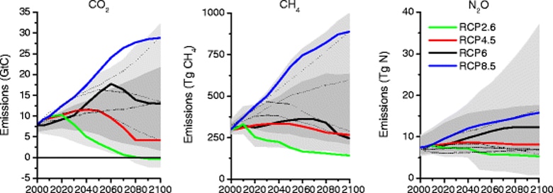
Heat is one of the biggest factors that change the niche of human habitability. Scientists expect that under the RCP 8.5 scenario, between 2040 and 2060 extreme temperatures will be common in the South and Southwest.
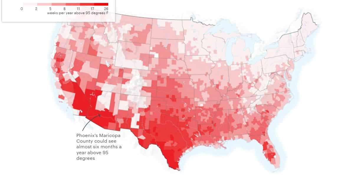
The future climate map below shows how Phoenix’ Maricopa county in the US will experience temperatures above 95 degrees for 6 months.
- Concept defined: RCP 8.5 is an extreme warming scenario that also means high-emissions scenario that’s often referred to as “business as usual”. It suggests that’s a likely outcome if the world doesn’t make concerted efforts to reduce GHG emissions. It’s the worst-case scenario in a no-climate policy world.
New Climate Maps: The “Wet Bulb” Temperatures
While heat is a key climate factor, alone it won’t determine the future of Americans. The new climate maps that show a transformed United States include also humidity alongside heat.
Taken together, they form the “wet bulb” temperatures that will disrupt the daily existence of Americans.
- Concept defined: Wet bulb temperature is the lowest temperature to which air cools down by the evaporation of water into the air at a constant pressure. It accounts for both heat and humidity in projecting temperature.
Though the dangers of wet bulb temperature is still rare today, it can be three decades from now. That’s assuming that people continue to dump more planet-warming gases.
Sample scenarios of new climate maps below show how the United States will be transformed under moderate (RCP 4.5) and high emissions (RCP 8.5). The projections include scenarios under five different phenomena.
Extreme Heat and Humidity: 2040-2060
Once heat meets excessive humidity, the body can no longer cool itself by sweating. That is the case with wet bulb temperatures.
In perspective, it’s when 82 degrees brings southern Alabama to its hottest temperature. So, working outdoors and playing school games can be both dangerous under this climate.
- And as wet bulb temperatures rise even more, so is the risk of heat strokes that may lead to deaths.
In both climate maps below, heat and humidity in Missouri (A) will feel like Louisiana today. Meanwhile, southwestern Arizona (B) that’s usually not that humid will witness rising wet bulb temperatures.
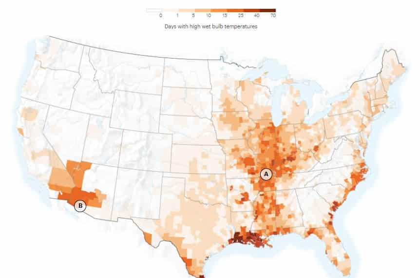
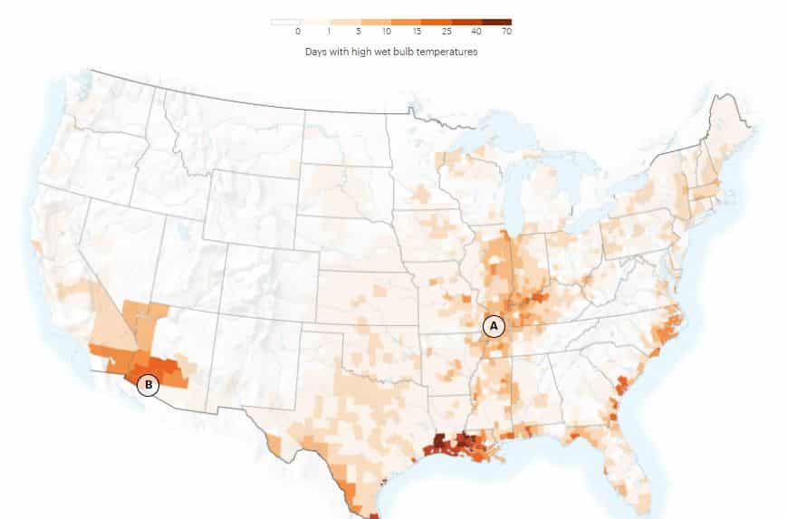
What most likely cause such a big change are many factors that react to high temperatures such as wind speed, sun angle, and cloud cover.
Large Wildfires in the US: 2040-2060
Wildfires are also another major evidence of changing climate maps of transformed United States. The chance that huge wildfires (fires that burn ~12,000 acres) affecting the country will increase even more with heat and worsening drought.
The last two years, 2020 and 2021, saw record-breaking wildfires engulfing the West, Northwest, and the Rocky Mountains. Even parts of the Southeast and Georgia are experiencing large wildfires that weren’t seen before.
- In fact, researchers estimate that by 2050, the northern Great Basin (A) which is not a dense forested region, will be the focal point of large wildfires.
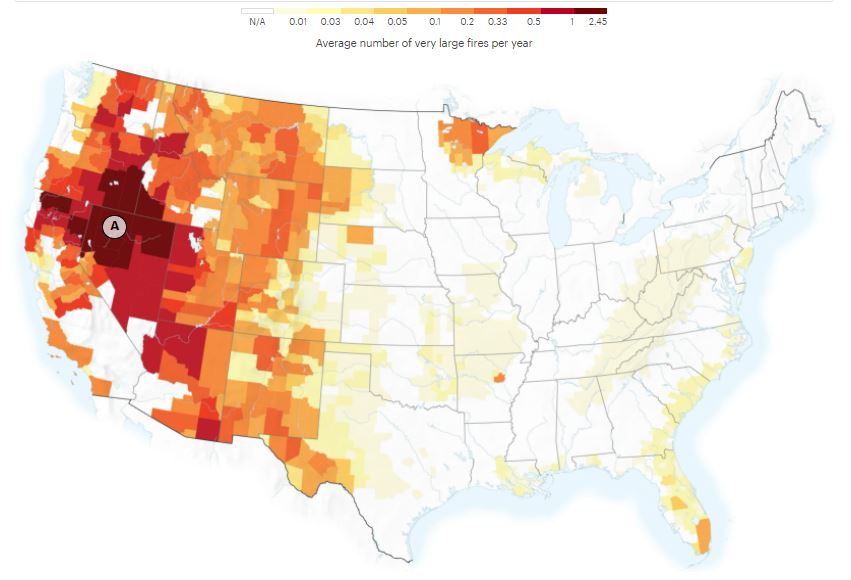
That region where big Nevada and Oregon counties will experience wet and dry weather cycles. This can turn the grasslands into a fuel field for fires that can spread through 10,000 acres in a day with strong winds.
Sea Level Rise: 2040-2060
When it comes to sea levels, they’re also rising rapidly. As per the National Oceanic and Atmospheric Administration (NOAA), the rate at which they rise has more than doubled from 2006 to 2015.
NOAA also predicts that sea levels will likely rise by at least 1 foot (0.3 m) above the levels seen in 2000 by the start of the next century. This means high tides in the coming decades will submerge even more properties along the coastlines.
Though this will affect a small land part of the country, it will impact a large share of the population. As illustrated in the new climate map, some of the populous cities in the US will be affected.
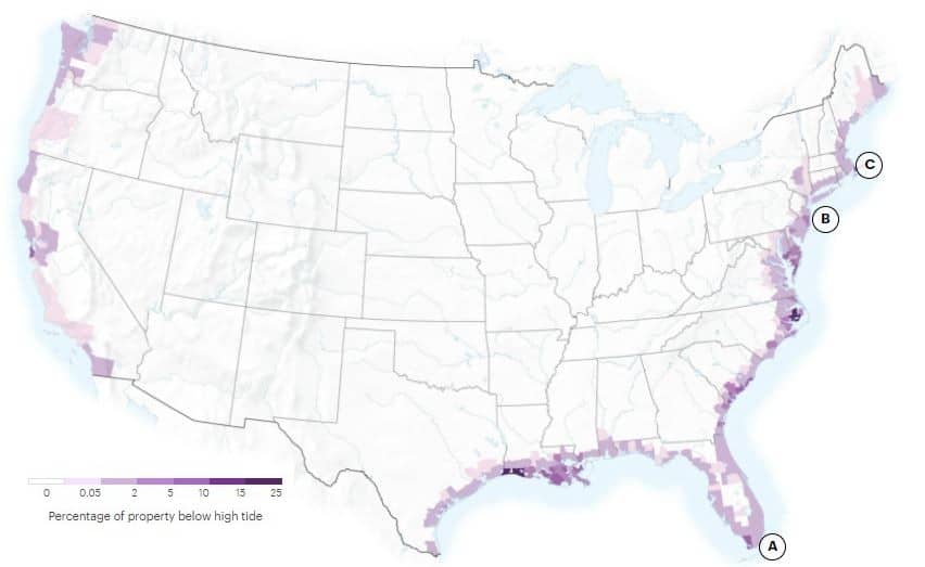
About 50 million people are living in America’s metro areas. And that include Miami (A), New York (B), and Boston (C). They’re all found in counties where higher share of properties will be below high tide.
So if you or someone you know happen to live in those areas, pay attention to the rising sea levels.
Farm Crop Yields in the US: 2040-2060
Apart from wild forests and oceans, agricultural lands will also be severely harmed by the climate change.
The rate of desertification grew a lot, turning plenty of croplands into dry lands. With more warming, it will be even more difficult to grow food.
Corn and soy are the most dominant crops in the US and are vital for livestock feed and other staple foods. As such, they have high economic value.
Because they’re taking most of the croplands in the country, corn and soy production is often used to predict how rising temperatures impact farming.
As growing both crops is more sensitive to heat than drought, their production rate will go down for each degree of warming.
In a sense, North Dakota (A in the map) can expect to have higher yields for both crops. That’s because the place will experience warmer temperatures by midcentury. But parts of Texas and Oklahoma (B) may witness declining yields by ~70% under high emissions scenario.
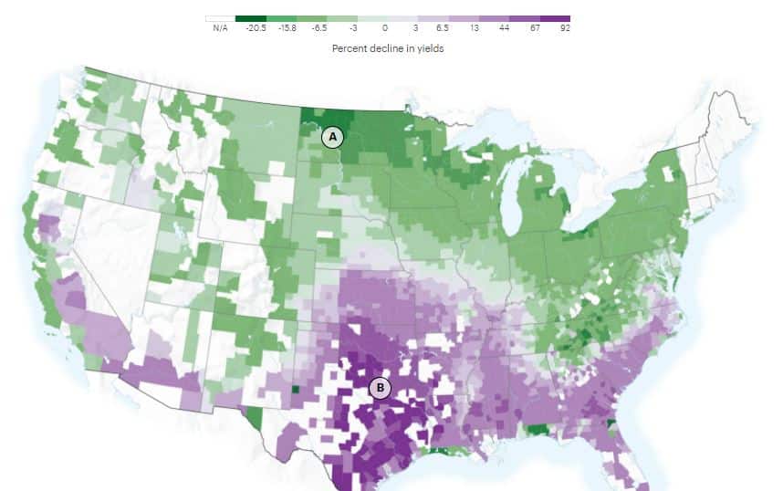
If you’re farming in the southern regions in the map (B), your production will face challenges if the projection holds true.
Climate Change Economic Damages: 2040-2060
Lastly, climate-driven changes will also take a financial toll on the US economy. The researchers determined the economic damages as a share of the counties’ GDP. The previous maps showing a transformed United States due to climate change can also tell.
The dragging effects of climate change to the American economy are due to several factors. These include the following:
- rising energy costs,
- lower labor productivity,
- poor crop yields, and
- increasing crime
Overall, under a high emissions scenario, the US economy will lose between about 1% – 4% of GDP each year by the end of the century. The effects, however, will not be the same across the country as shown in the map.
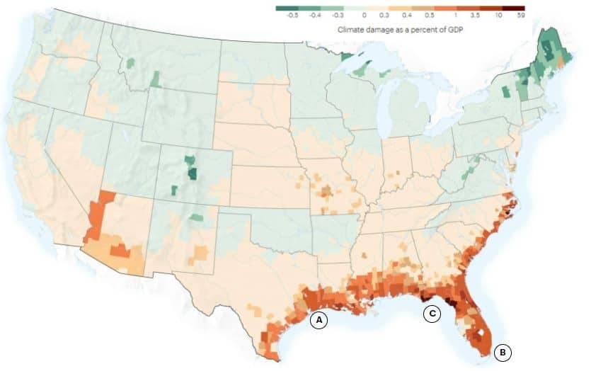
For example, populous areas with expensive real estate like Houston (A) and Miami (B), will see economic losses in billions. That corresponds to several percentage points loss in their GDP.
What will cause such a big financial loss are rising sea levels, storms, and even deaths from extreme heat, according to the researchers.
More notable is the fact that climate change damages will be worse in poorer and rural areas. Take the case of the Gulf Country, Florida (C), for instance. They may lose even half of their economy due to those climate-related disasters.
Are Those Future Scenarios Unavoidable?
Without a doubt, those climate maps that show a transformed United States from today look scary.
Oceans swallowing more coastal lands are unimaginable while deaths due to heat strokes are more unthinkable.
Not to mention the fierceness of large wildfires claiming vast acres of land and even lives. And the idea of low food supply may prompt you to think of hoarding food today. These compounding climate change calamities seem to be like the end of world.
But the good news is that humans still have a chance to avoid them with suitable climate policies and prompt actions. The deadline is quite tight though.
Organizations and individuals alike are looking for ways to prevent those disastrous scenarios.
People develop initiatives that avoid greenhouse gas emissions.
Companies innovate technologies that remove carbon and other GHG already dumped in the air.
Nations take measures that cut down their emissions.
Investors fund projects that support all those actions above.
If you are interested in how you can join and help address climate change and reverse its catastrophic effects, there are plenty of means to do so.
But if you’re looking for a way that can both benefit the planet and your wallet, you can start by exploring the carbon market.
You can visit our education page for comprehensive guidelines all about carbon market. It’s best to begin with this beginner’s guide explaining the voluntary carbon market.